Map - Lelystad (Gemeente Lelystad)

Lelystad (Gemeente Lelystad)
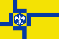
Lelystad is a municipality and a city in the centre of the Netherlands, and it is the capital of the province of Flevoland. The city, built on reclaimed land, was founded in 1967 and was named after Cornelis Lely, who engineered the Afsluitdijk, making the reclamation possible. Lelystad is approximately 3 m below sea level.

Lelystad is built on the seabed of the former Zuiderzee. About 6500 years ago this wetland was above high tide level and inhabited; the Netherlands have steadily subsided since. Near Lelystad at Swifterbant, the oldest human skeletons in Western Europe were discovered. Due to rising water levels and storms, the peatlands were washed away, and the Lacus Flevo (in Roman times) grew to be the Almere (Middle Ages) and became the Zuiderzee. The Zuiderzee (Southern Sea) was the main transport route from Amsterdam to the North Sea and the Hanseatic League cities. Due to the many shipwrecks in Flevoland, Lelystad now houses the National Centre for Maritime History, with a museum and the shipyard that has built the Batavia replica.

After the Second World War the Zuiderzee Works continued, constructing the polder of Eastern Flevoland. In 1950 work commenced on several construction islands in the middle of the IJsselmeer. Lelystad-Haven was the largest island, and its wooden barracks housed a community of dyke-builders. In 1955 they reached the mainland, which made it possible to drive to Lelystad by car. One of the three pumping stations, which drained the polder in June 1957, was the diesel-powered Wortman in Lelystad-Haven. Until 1967 the only inhabitants of Lelystad were technical engineers and laborers and superintendents, living on the former construction island.

 
Map - Lelystad (Gemeente Lelystad)
Map
Google Earth - Map - Lelystad
Google Earth
Openstreetmap - Map - Lelystad
Openstreetmap
Map - Lelystad - Esri.WorldImagery
Esri.WorldImagery
Map - Lelystad - Esri.WorldStreetMap
Esri.WorldStreetMap
Map - Lelystad - OpenStreetMap.Mapnik
OpenStreetMap.Mapnik
Map - Lelystad - OpenStreetMap.HOT
OpenStreetMap.HOT
Map - Lelystad - OpenTopoMap
OpenTopoMap
Map - Lelystad - CartoDB.Positron
CartoDB.Positron
Map - Lelystad - CartoDB.Voyager
CartoDB.Voyager
Map - Lelystad - OpenMapSurfer.Roads
OpenMapSurfer.Roads
Map - Lelystad - Esri.WorldTopoMap
Esri.WorldTopoMap
Map - Lelystad - Stamen.TonerLite
Stamen.TonerLite
Country - Netherlands
The Netherlands (Nederland ), informally Holland, is a country located in Northwestern Europe with overseas territories in the Caribbean. It is the largest of four constituent countries of the Kingdom of the Netherlands. The Netherlands consists of twelve provinces; it borders Germany to the east, and Belgium to the south, with a North Sea coastline to the north and west. It shares maritime borders with the United Kingdom, Germany and Belgium in the North Sea. The country's official language is Dutch, with West Frisian as a secondary official language in the province of Friesland. Dutch, English and Papiamento are official in the Caribbean territories.

The four largest cities in the Netherlands are Amsterdam, Rotterdam, The Hague and Utrecht. Amsterdam is the country's most populous city and the nominal capital. The Hague holds the seat of the States General, Cabinet and Supreme Court. The Port of Rotterdam is the busiest seaport in Europe. Schiphol is the busiest airport in the Netherlands, and the third busiest in Europe. The Netherlands is a founding member of the European Union, Eurozone, G10, NATO, OECD, and WTO, as well as a part of the Schengen Area and the trilateral Benelux Union. It hosts several intergovernmental organisations and international courts, many of which are centred in The Hague.
Currency / Language  
ISO Currency Symbol Significant figures
EUR Euro € 2
Neighbourhood - Country  
  •  Belgium 
  •  Germany 
Administrative Subdivision
City, Village,...